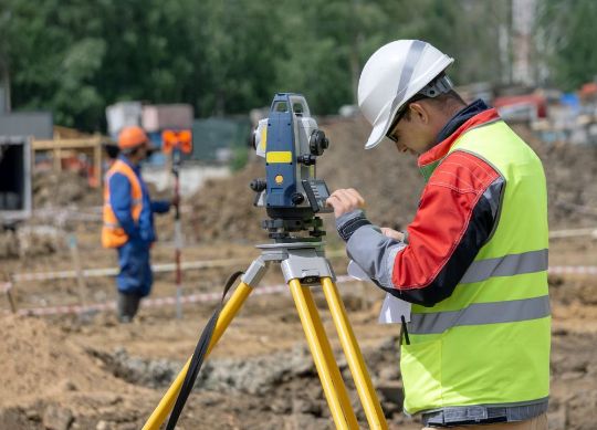
Point Cloud Management

In collaboration with various entities, we specialize in data capture through 3D scanning. We employ advanced technology to perform point cloud scans and generate accurate and detailed images.

We provide comprehensive and efficient solutions for your projects. From data capture to BIM modeling, we ensure to deliver high-quality results that optimize your design, planning, and execution processes.

OUR TEAM IS HERE TO HELP YOU FIND THE EXACT SERVICE FOR THE APPLICATION YOU NEED

STATIONARY SCANNING

3D scanning using tripod-mounted equipment is one of the most precise and widely used techniques in the field of architecture and construction. This method involves taking readings from different points of the analyzed area, similar to the total stations used by surveyors.

The versatility of this approach allows it to adapt to the complexity and size of the site, which may require the creation of multiple point clouds. These point clouds are then processed and merged in the technical office to form a complete and detailed 3D model.

The combination of accurate 3D scanning equipment and meticulous work in the technical office ensures highly precise and comprehensive results. This technique provides a valuable tool for documentation, planning, and design of architectural and construction projects, offering a detailed view of the environment and optimizing work processes

MOVIL
 SCANNING

The equipment used in mobile scanning is compact and increasingly lightweight, allowing the operator to easily move it while following a predefined path.

This path typically starts and ends at the same point in the space being analyzed.

The scanning strategy is crucial in mobile scanning to ensure proper overlap between different paths, ensuring a complete and coherent representation of the scanned space.

This technique is especially useful for capturing data in places where stationary scanning is not possible, such as complex interior spaces, areas with many obstacles, or sites with irregular terrain. Combined with appropriate processing techniques, highly detailed and useful results can be obtained for architectural, construction, and engineering projects.

AERIAL
SCANNING

Aerial scans using drones are especially valuable in civil engineering projects, where a detailed analysis of terrain, railway lines, roads, and other infrastructure elements is required.

The speed and efficiency with which drones can capture this data, combined with their ability to access hard-to-reach areas, make them a valuable tool for project planning and execution.

The point cloud obtained from aerial scans serves as a solid foundation for the design and analysis of construction and engineering projects, enabling informed and accurate decision-making.

With the proper use of technology and planning, aerial scans using drones provide highly detailed and reliable results for a wide range of applications.

We use cookies
Cookie preferences
Below you may find information about the purposes for which we and our partners use cookies and process data. You can exercise your preferences for processing, and/or see details on our partners' websites.
Analytical cookies Disable all
Functional cookies
Other cookies
We use cookies to personalize content and ads, to provide social media features and to analyze our traffic. Learn more about our cookie policy.
Accept all Decline all Change preferences
Cookies